Dr Chris Naunton, 22nd November 2025
‘There are also double sets of chambers, three thousand altogether, fifteen hundred above and the same number underground.’ (Herodotus, Book II, 148)
This lecture, which was held at St Thomas’s Community Centre – a location that was labyrinthine for a few of us in terms of finding it – took us to the land of Faiyum. The city still exists and is about 62 miles southwest of Cairo, a location very important during the Middle Kingdom. Dr Naunton took us through the background to this location before exploring the labyrinth’s history and excavation. So, seat belts on as it was a whistlestop tour!
Middle Kingdom
Although the first mentions of this labyrinth are during the Persian Dynasty, the labyrinth predates this time by nearly 2,000 years. The Middle Kingdom – covering the latter Pharaohs of the 11th Dynasty, all the Pharaohs of the 12th Dynasty, plus the start of the 13th Dynasty. However, it’s the 12th Dynasty that matters to us as Dr Naunton took us through each Pharaoh, who was either called Amenemhat or Senwosret. Here goes:

Amenemhat I – the start of the new dynasty who experienced attempted assassinations and moved his capital from Thebes to Itj-Tawy (actually called Amenemhat -Itj-Tawy) – we don’t know where that was, but probably near the area known as the Faiyum. He united Egypt and eventually had a co-regency with his son, Senwosret I, who then succeeded him. Their pyramids are located at Lisht – north towards Memphis.
The Faiyum becomes very important during this period, especially in terms of building projects. Rapid development of the area was made possible because the flood level lowered, exposing a substantial area of land for cultivation and for building. During the 12th Dynasty an irrigation canal was built to feed into the Faiyum. This created a better lake – known as The Lake – the hieroglyphs for this give us the name Faiyum!

Amenhemhat I and his son, Senwosret, added to a pre-existing temple of Sobek in Shedet (now Medinet El Faiyum).
Amenhemhat II – pyramid in Dahshur along with Amenhemhat II.

Senwosret II and III broke tradition and their capital was in Lahun, rather than Itj-tawy. Sen III pyramid was in Dahshur, Sen II in Lahun. By this stage the pyramids were made of mud brick then covered in bright white limestone. Old Kingdom pyramids were much bigger but less complex inside. Middle Kingdom are smaller but more complex inside – probably to deter robbers…but that’s not the labyrinth!
Amenhemhat III was a co-regent with his father Sen III and had a pyramid at Hawara, along with a labyrinth by the side of the canal. He became known in later times as the King Lamares of Moeris (the big canal!). He was known as a great builder.
Excavations
1800 – survey conducted by the Napoleon expedition.
1820s – survey by John Gardner Wilkinson
1837 – survey by Howard Vyse and John Perring
1840s – excavation by Lepsius expedition
1862 – excavation by Vassalli
1988-89 – serious work done by Flinders Petrie – excavations and survey
1911 – excavation of the labyrinth area and pyramid by Petrie – uncovered some of the most remarkable sculptures fragments.
The pyramid had a blind passageway with corridors blocked by hard stone portcullises along twisting corridors – the solid block portcullises were dropped in place through the use of sand hydraulics set in motion as people left the burial chamber and pyramid. The waterlogged burial chamber had been excavated by Petrie in 1988-89. There was very little left: despite the obstacles robbers had got in. The blocks were an exceptionally tight fit so no real idea how they managed to get in!
The Labyrinth
The labyrinth was a building attached to the pyramid. We know about it through the writings of classical authors, who saw it as an extraordinary feat of building. (I have put website links to the text where I can.)
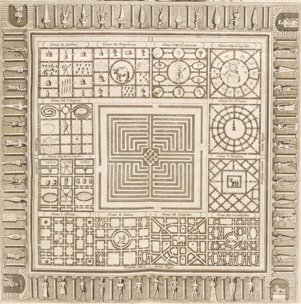
Herodotus Book II, 148 exaggerated the number of rooms: ‘There are also double sets of chambers, three thousand altogether, fifteen hundred above and the same number underground.’ He also spoke about the ‘carven figures’ in the walls and how, ‘every court is set round with pillars of white stone most exactly fitted together’.
Diodorus Siculus The Library of History Book 1, 89 refers to the Lake of Moeris and the labyrinth.
Strabo Geography Book XVII, 37 gives a description of the labyrinth.
Early excavations in the 19th Century were aware of these reports, indeed Strabo’s description guided the explorers to Hawara. The remains of the labyrinth can be seen in the form of red lumps of stone near the pyramids, the remains of columns.
Petrie proposed site maps for how the labyrinth would have looked. He came to the conclusion that its size would accommodate many of the pyramids and temples in Egypt with room to spare.
Eric Uphill refers to the labyrinth as ‘Pharaoh’s Gateway to Eternity’ – which is the name of his book.
More news may come out in the future as the Labyrinth Research Project is using Transient Electromagnetic (TEM) techniques to survey the area to try and recover more information about the labyrinth.
Dr Chris Naunton has his own website page about the labyrinth and it can be accessed here for more resources.
[The hieroglyphs represent Amenemhat, Faiyum Lake Land and Senwosret respectively.]
Views: 45